Flooding poses a significant threat to transport networks in Southeast Asia. The region’s low-lying cities are particularly vulnerable to intense monsoon rains and tropical storms. Climate change is expected to increase precipitation intensity, leading to more frequent and severe flooding. This heightened flood risk threatens the region’s critical infrastructure, including roads, bridges and railways.
Riverine flooding in particular – from rivers or streams – significantly impairs transport accessibility to medical facilities in Southeast Asia, exacerbating public health crises during flood events. The inundation of roads and bridges disrupts transportation networks, making it challenging for emergency services to reach affected areas and for patients to access critical medical care promptly.
Using the OpenStreetMap (OSM) road network and hospital locations, we simulated routes and driving times from randomly selected locations to the closest hospitals in Cambodia, Lao PDR, Myanmar, Thailand and Viet Nam. We then computed the shortest routes under two scenarios: with and without flooding where, depending on the projected inundation level (meters), roads may be blocked or accessed at a much slower speed. In total, we analyzed driving times to 2,621 hospitals from 26,210 locations.
As expected, the simulated driving times to the closest hospitals during floods increased dramatically across the five economies compared to non-flood scenarios. Overall, 40% of locations experienced longer driving times. 17% of locations lost road access to hospitals, as roads that are normally passable become completely impassable during floods (defined in literature as 0.3 meters or above). The average driving time to the closest hospitals increased by 38%, from 14 to 19 minutes (Table 1).
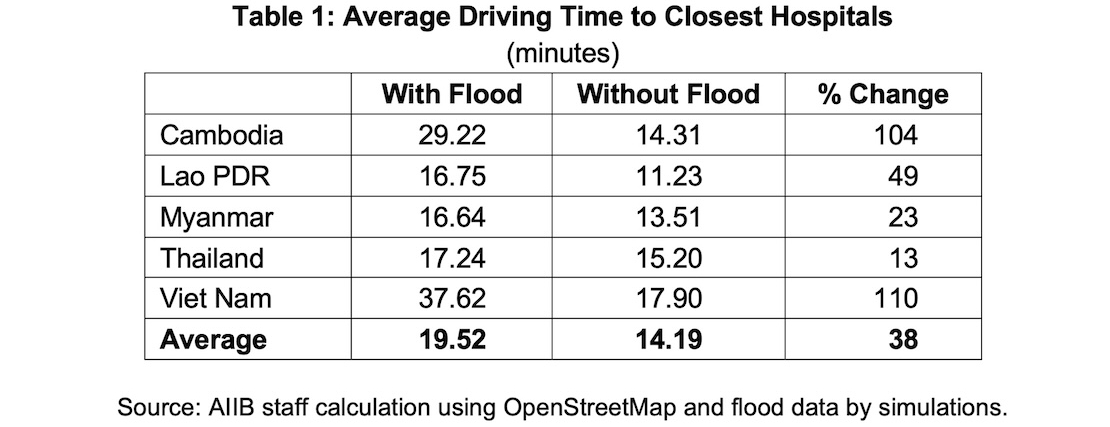
Viet Nam appears to be the most affected by prolonged or lost road access to hospitals during flooding. The driving time to the closest hospitals more than doubled in our simulation, with one-third of locations losing medical accessibility completely. These observations align with recent reports indicating that urban road networks in Viet Nam are particularly vulnerable to floods and other associated natural disasters such as landslides.
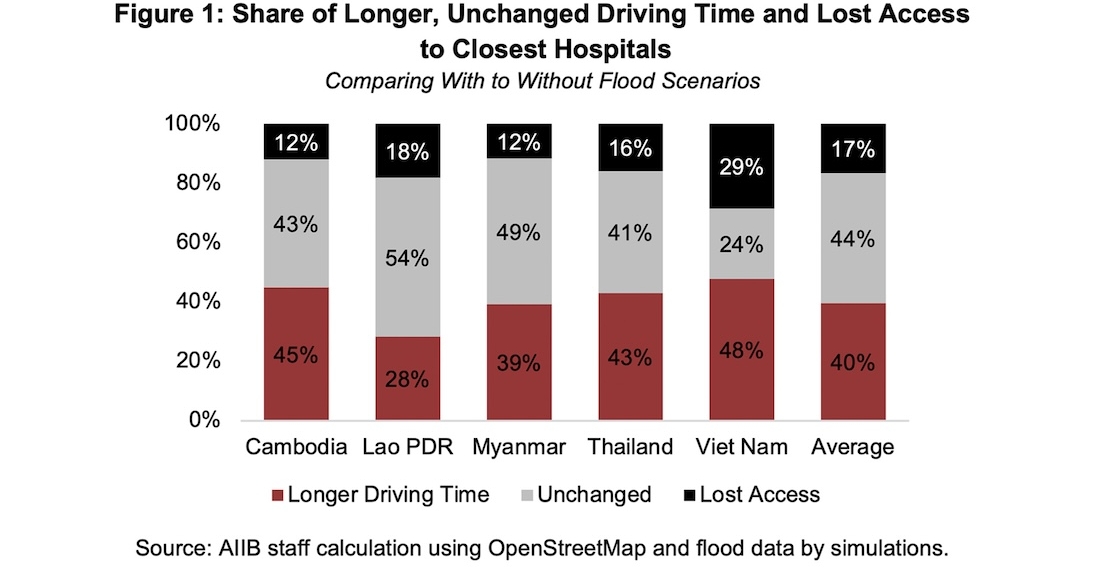
Figure 2: Scatterplot of Driving Time to Closest Hospitals

Source: AIIB staff estimates using OpenStreetMap and flood data by simulations.
Results for Cambodia were similar to those in Viet Nam, although Cambodia has a much lower share of points (12%) losing medical accessibility during flooding (Figure 1). Thailand seems to be relatively resilient, with the average driving time to the closest hospitals increasing by only 13%, from 15.2 to 17.2 minutes. In Lao PDR and Myanmar, driving time during flooding increased by 49% and 23%, respectively, in our simulation, but a lower share of locations experienced such prolonged travel to hospitals.
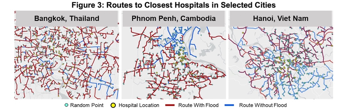
Figure 3 illustrates the driving routes to the closest hospitals in Bangkok, Phnom Penh and Hanoi under both normal and flood scenarios. Consistent with the results above, most driving routes in Bangkok remained the same, albeit with lower speeds due to floods. In contrast, many routes in southeast Hanoi and riverside areas in northern Phnom Penh became unavailable during the simulated flood scenario. The population in these low-elevation, flat riverside areas is the most vulnerable to disrupted road accessibility to hospitals when flooded.
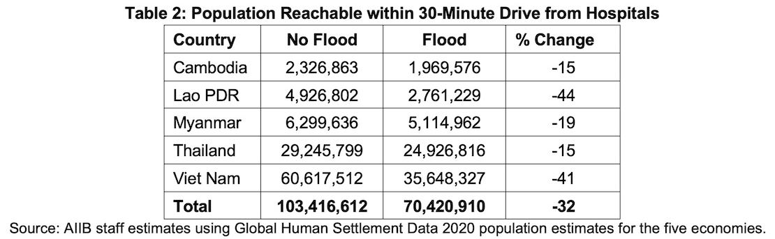
The simulation also computed the number of people reachable within a 30-minute drive from all 2,621 selected hospitals under normal and flood scenarios (Table 2). Without floods, around 103 million people can be reached within 30 minutes of nearby hospitals. However, during the simulated flood scenario, this number significantly declined by more than 30% to 70.3 million. Viet Nam and Lao PDR were the most affected, with 40% fewer people reachable within 30 minutes.
As Southeast Asia continues to urbanize and develop, enhancing flood resilience and the adaptive capacity of transport infrastructure becomes imperative to mitigate these impacts and ensure sustainable development.
This article is adapted from a geospatial study of medical accessibility in flood conditions in Chapter 3: In Deep Water—Climate Change Impacts on Water Systems and Human Health of the report Asian Infrastructure Finance 2025: Infrastructure for Planetary Health.
